
Development Studies
The Economic and Development Services Department undertakes development studies to help guide future growth in the City.
Current studies
Official Plan
The Oshawa Official Plan sets out the land use policy directions for long-term growth and development in the city, and manages and guides the physical form and growth of the city.
Regular reviews of the Oshawa Official Plan ensure it continues to meet the City's changing needs and complies with the Durham Regional Official Plan and Provincial policies. Changes to the Official Plan are sometimes required to allow new development or redevelopment.
If your project does not comply with the Oshawa Official Plan, you may need to revise your plans to comply or submit an Application for an Official Plan Amendment through the Oshawa Application Portal. In addition to the Oshawa Application Portal submission, one original hard copy of the application form must be commissioned and mailed/dropped off to Planning Services, as well as 2 hard copies of all submission materials.
One of the reports required with an application to amend the zoning by-law is a Planning Justification Report. For terms of reference for this report please visit the Development Applications webpage.
Imagine Oshawa:
Let’s plan our City’s
future together

The City of Oshawa is undertaking a comprehensive review of its Official Plan – the blueprint sets out the land use policy directions for long-term growth and development for how Oshawa will grow for years to come – and we want to hear your ideas!
To help generate ideas, the City’s Planning Services department has prepared a Discussion Paper about the Official Plan Review that explains why the Official Plan is important, provides details about the Official Plan Review process and identifies potential key themes that will be explored.
Growth Management Study
A key part of the Official Plan Review is a Growth Management Study, which will explore when, where and how future growth and development should happen in Oshawa. This includes planning for land uses and infrastructure to meet our needs today and in the future - and we need your help to set the course!
A Growth Management Study Discussion Paper has been prepared, which is intended to introduce the Growth Management Study to the public and provide key information to help and encourage interested parties to understand, participate and provide meaningful input to the Study.
Complete the Growth Management Study feedback form. Feedback may be submitted up to noon on Friday, August 1, 2025. Your input will help the project team to understand your current level of familiarity with the Official Plan and the City’s planning framework, and shape how we engage with the community throughout the Growth Management Study and Official Plan Review process.
| Resources |
The following is a list of staff reports that have been prepared for the Official Plan Review:
|
For more information, please visit Connect Oshawa at connectoshawa.ca/OPReview or email [email protected].
Integrated Major Transit Station Area Study for Central Oshawa
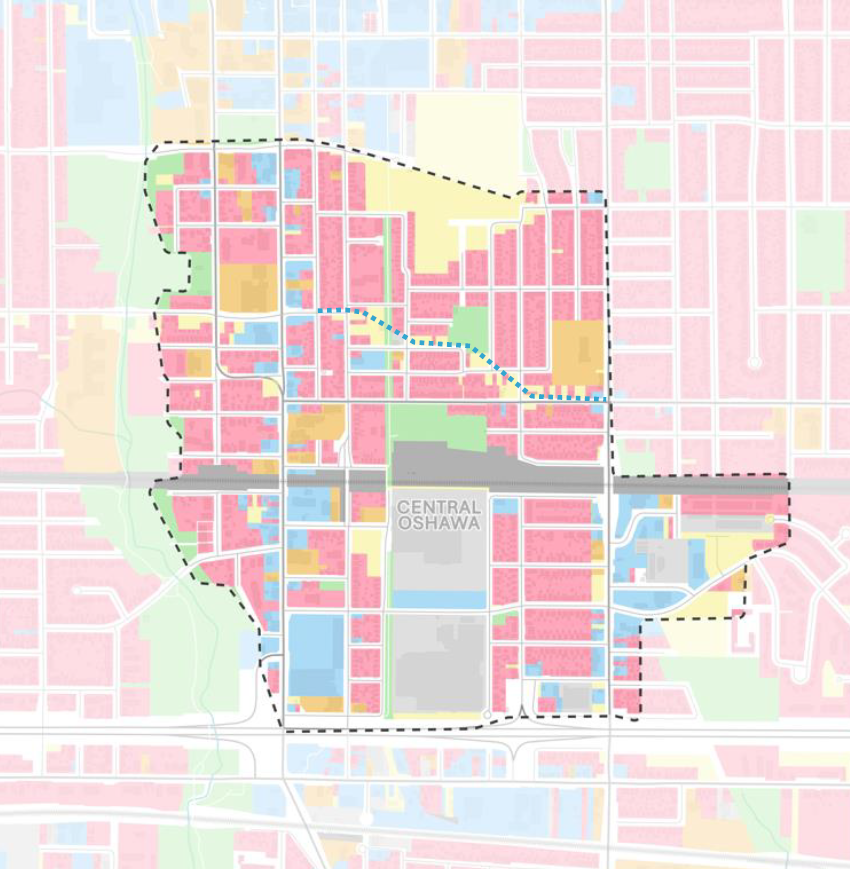
The City of Oshawa has retained Parsons Inc. to complete the Integrated Major Transit Station Area Study for Central Oshawa (Integrated M.T.S.A Study). The City of Oshawa is growing, and the Province of Ontario is guiding growth to places that can support it. One of these places are Major Transit Station Areas. These areas are typically within a 500-800m radius from a transit stop or station and are generally located along existing or planned transit corridors.
The Central Oshawa M.T.S.A was identified by the Region of Durham through their Municipal Comprehensive Review of the Durham Regional Official Plan. The Integrated M.T.S.A. Study is in response to the announced Lakeshore East GO Rail Corridor extension to Bowmanville and the planned Central Oshawa GO Station, at 500 Howard St., located in the core of the M.T.S.A., along the Canadian Pacific Belleville Mainline.
The overall Study area is generally bound by John St. and Eulalie Ave. to the north, Ritson Rd. S. to the east, Highway 401 to the south, and the Oshawa Creek Valley to the west (see map at right).
The purpose of the Integrated M.T.S.A. Study is to undertake:
- A Master Land Use and Urban Design Plan to advance appropriate development and intensification in the M.T.S.A.
- An Area-specific Transportation Master Plan (T.M.P.) to identify and recommend a preferred transportation option that accommodates future development. The T.M.P. will follow the Municipal Class Environmental Assessment (M.C.E.A) process for Master Plans, in accordance with the Environmental Assessment Act.
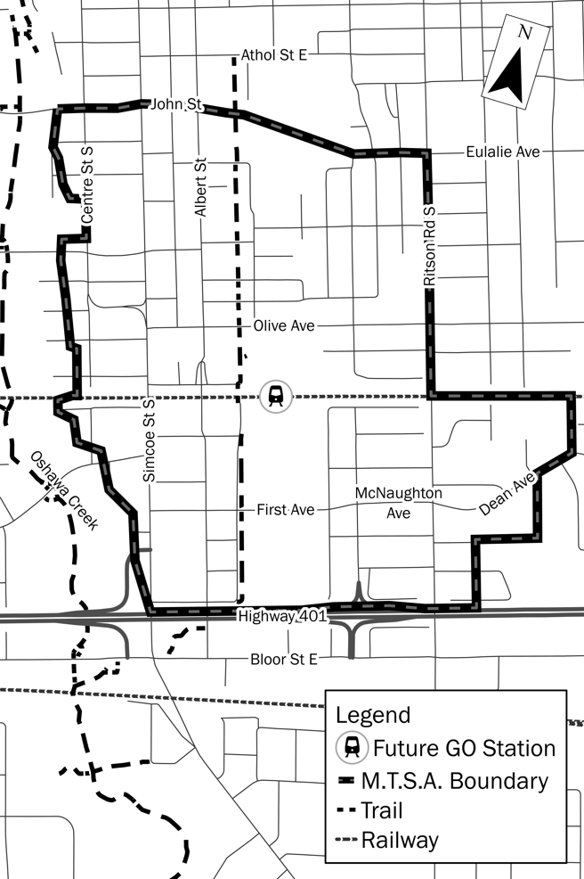 Integrated M.T.S.A. Study Area Map
| Study Timeline |
|
Notice of Study Commencement was issued on November 24, 2022. In Fall 2022 and Winter 2023, Parsons completed the background review and analysis within Stage 1 in preparation for Public Information Centre (P.I.C.) #1. Notice of P.I.C. #1 was issued on January 5, 2023. P.I.C. #1 was held on February 2, 2023. Public and stakeholder feedback for Stage 1 was received until February 16, 2023, and was considered in Report ED-23-47 dated March 1, 2023 by the Economic and Development Services Committee and Council on March 6 and April 3, 2023, respectively. Council authorized the initiation of Stage 2 of the Study on April 3, 2023. In Spring 2023, Parsons advanced the Stage 2 deliverables for the Study, including:
P.I.C. #2 was held on June 28, 2023 to present information and gather feedback on the above items. The public consultation window for Stage 2 ran from May 25 to July 21, 2023. Stage 2 feedback was considered in Report ED-23-167 dated September 6, 2023 by the Economic and Development Services Committee and Council on September 11 and October 2, 2023, respectively. Council authorized the initiation of Stage 3 of the Study on October 2, 2023. P.I.C. #3 for Stage 3 of the Study was held on April 23, 2024 to present information and gather feedback on the following items;
The public consultation window for Stage 3 ran from April 8 to May 17, 2024. Stage 3 feedback was considered in Report ED-24-72 dated May 29, 2024 by the Economic and Development Services Committee and Council on June 3 and 24, 2024, respectively. Council authorized the initiation of Stage 4 of the Study on June 24, 2024. |
| Study Documents - Stage 1 |
|
The following is a list of background materials and reports for Stage 1 of the Integrated M.T.S.A. Study:
|
| Study Documents - Stage 2 |
|
The following is a list of background materials and reports for Stage 2 of the Integrated M.T.S.A. Study:
|
|
Study Documents - Stage 3 |
|
The following is a list of background materials and reports for Stage 3 of the Integrated M.T.S.A. Study:
* Due to the large file size, the attached drawings and appendices of the Preliminary Hydrogeological Investigation and the Natural Environment Report, as well as Appendix B, C and D of the Contamination Overview Study, are not available online. Please contact [email protected] if you wish to obtain the full documents. ** Once preliminary designs for First/McNaughton Avenue have been finalized, these reports will be updated to include a preliminary impact assessment and mitigation recommendations, where appropriate. |
| Study Documents - Stage 4 |
The following is a list of background materials and reports for Stage 4 of the Integrated M.T.S.A. Study:
* Due to the large file size, the attached appendices of the Stormwater Management of First Ave. & McNaughton Ave. Environmental Study are not available online. Please contact [email protected] if you wish to obtain the full document. |
| Public Consultation |
|
Public participation and feedback are key components of the Integrated M.T.S.A. Study. There will be a series of Public Information Centres (P.I.C.) planned throughout the Study. P.I.C. #3 was held on April 23, 2024. The public consultation window for Stage 3 ran from April 9, 2024 to May 17, 2024. Stage 3 feedback was considered in Report ED-24-72 dated May 29, 2024 by the Economic and Development Services Committee and Council on June 3 and 24, 2024, respectively. Council authorized the initiation of Stage 4 of the Study on June 24, 2024. P.I.C. #4 is anticipated to be scheduled in the first quarter of 2025 to consider the fourth stage of the First/McNaughton Avenue Municipal Class Environmental Assessment, including the 30% road design and the Area-specific Transportation Master Plan. It is also anticipated that a statutory Planning Act public meeting will be scheduled for Spring 2025 to consider amendments to the Oshawa Official Plan and Zoning By-law. |
| Contact Us |
|
You can submit your comments or questions at any time to the key contacts listed below: Connor Leherbauer, RPP Paul Croft, MCIP, RPP Yannis Stogios, P.Eng. |
| Protection of Privacy and Accessibility |
|
Information is collected in accordance with the Freedom of Information and Protection of Privacy Act. With the exception of personal information, all comments become part of the public record. The City of Oshawa is committed to providing services as set out in the Accessibility for Ontarians with Disabilities Act, 2005. If you have accessibility needs and require alternate formats or other accommodations, please contact the City contact listed under "Contact Us" above. |
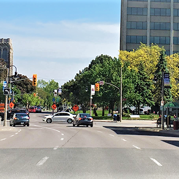
Simcoe Street Rapid Transit Visioning Study
The Region of Durham’s 2017 Transportation Master Plan and Metrolinx’s 2041 Regional Transportation Plan both identify the need for a rapid transit corridor along Simcoe Street between Highway 407 and the proposed Ritson GO Station in the City of Oshawa.
In order to identify the most suitable form of rapid transit for the Simcoe Street corridor, the Region of Durham is initiating the Simcoe Street Rapid Transit Visioning Study. The Simcoe Street Rapid Transit Visioning Study is an opportunity to learn how to improve mobility and quality of life for existing residents while preparing the corridor to attract and support future growth.
This Study will investigate opportunities to realistically assess rapid transit investments based on evolving best practices in the areas of diversity, equity and inclusion including the equity economic benefits of rapid transit and Transit-Oriented Communities concepts.
The primary objective of the Study is to develop a concept plan, including preferred stations and connections, and a supportive rapid transit service strategy for Simcoe Street. The Study will also consider future transit planning initiatives by Metrolinx, transit agencies and regional and municipal authorities.
Study Area
The Study Area will be focused primarily along Simcoe Street between Highway 407 and Olive Avenue in the City of Oshawa.

Join the conversation
Visit the Region of Durham's Study Webpage to:
- Learn more about the study
- Sign up for the mailing list
- Stay up to date on key milestones and opportunities to get involved
Completed Development studies
To obtain information about a completed environmental assessment, please contact Engineering Services.
- Northwood Land Use study
- Oshawa Creek Design study
To obtain information about the following Development studies, please contact Planning Services:
- Integrated Columbus Part II Planning Act and Municipal Class Environmental Assessment Act Study
- Bloor-Simcoe Intensification Study
- Parking Study