Development Studies
The Economic and Development Services Department undertakes development studies to help guide future growth in the City.
Current studies
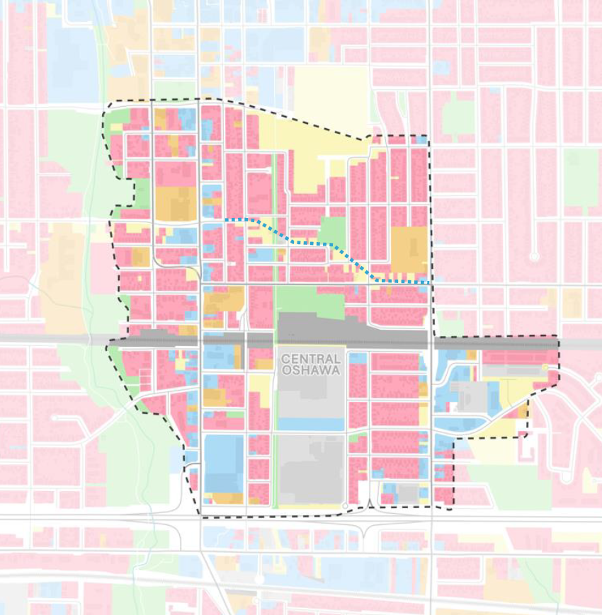
The City of Oshawa has retained Parsons Inc. to complete the Integrated Major Transit Station Area Study for Central Oshawa (Integrated M.T.S.A Study). The City of Oshawa is growing, and the Province of Ontario is guiding growth to places that can support it. One of these places are Major Transit Station Areas. These areas are typically within a 500-800m radius from a transit stop or station and are generally located along existing or planned transit corridors.
The Central Oshawa M.T.S.A was identified by the Region of Durham through their Municipal Comprehensive Review of the Durham Regional Official Plan. The Integrated M.T.S.A. Study is in response to the announced Lakeshore East GO Rail Corridor extension to Bowmanville and the planned Central Oshawa GO Station, at 500 Howard St., located in the core of the M.T.S.A., along the Canadian Pacific Belleville Mainline.
The overall Study area is generally bound by John St. and Eulalie Ave. to the north, Ritson Rd. S. to the east, Highway 401 to the south, and the Oshawa Creek Valley to the west (see map at right).
The purpose of the Integrated M.T.S.A. Study is to undertake:
- A Master Land Use and Urban Design Plan to advance appropriate development and intensification in the M.T.S.A.
- An Area-specific Transportation Master Plan (T.M.P.) to identify and recommend a preferred transportation option that accommodates future development. The T.M.P. will follow the Municipal Class Environmental Assessment (M.C.E.A) process for Master Plans, in accordance with the Environmental Assessment Act.
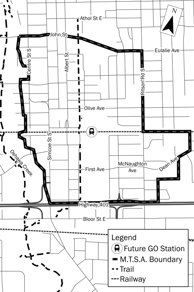
Integrated M.T.S.A. Study Area Map
Study Timeline |
Notice of Study Commencement was issued on November 24, 2022. In Fall 2022 and Winter 2023, Parsons completed the background review and analysis within Stage 1 in preparation for Public Information Centre (P.I.C.) #1. Notice of P.I.C. #1 was issued on January 5, 2023. P.I.C. #1 was held on February 2, 2023. Public and stakeholder feedback for Stage 1 was received until February 16, 2023, and was considered in Report ED-23-47 dated March 1, 2023 by the Economic and Development Services Committee and Council on March 6 and April 3, 2023, respectively. Council authorized the initiation of Stage 2 of the Study on April 3, 2023. In Spring 2023, Parsons advanced the Stage 2 deliverables for the Study, including:
P.I.C. #2 was held on June 28, 2023 to present information and gather feedback on the above items. The public consultation window for Stage 2 ran from May 25 to July 21, 2023. Stage 2 feedback was considered in Report ED-23-167 dated September 6, 2023 by the Economic and Development Services Committee and Council on September 11 and October 2, 2023, respectively. Council authorized the initiation of Stage 3 of the Study on October 2, 2023. P.I.C. #3 for Stage 3 of the Study was held on April 23, 2024 to present information and gather feedback on the following items;
The public consultation window for Stage 3 ran from April 8 to May 17, 2024. Stage 3 feedback was considered in Report ED-24-72 dated May 29, 2024 by the Economic and Development Services Committee and Council on June 3 and 24, 2024, respectively. Council authorized the initiation of Stage 4 of the Study on June 24, 2024. |
Study Documents - Stage 1 |
The following is a list of background materials and reports for Stage 1 of the Integrated M.T.S.A. Study:
|
Study Documents - Stage 2 |
The following is a list of background materials and reports for Stage 2 of the Integrated M.T.S.A. Study:
|
Study Documents - Stage 3 |
The following is a list of background materials and reports for Stage 3 of the Integrated M.T.S.A. Study:
*Once preliminary designs for First/McNaughton Avenue have been finalized, this Report will be updated to include a preliminary impact assessment and mitigation recommendations, where appropriate. |
Public Consultation |
Public participation and feedback are key components of the Integrated M.T.S.A. Study. There will be a series of Public Information Centres (P.I.C.) planned throughout the Study. P.I.C. #3 was held on April 23, 2024. The public consultation window for Stage 3 ran from April 9, 2024 to May 17, 2024. Stage 3 feedback was considered in Report ED-24-72 dated May 29, 2024 by the Economic and Development Services Committee and Council on June 3 and 24, 2024, respectively. Council authorized the initiation of Stage 4 of the Study on June 24, 2024. P.I.C. #4 is anticipated to be scheduled in Fall 2024. |
Contact Us |
You can submit your comments or questions at any time to the key contacts listed below: Connor Leherbauer, RPP Paul Croft, MCIP, RPP Yannis Stogios, P.Eng. |
Protection of Privacy and Accessibility |
Information is collected in accordance with the Freedom of Information and Protection of Privacy Act. With the exception of personal information, all comments become part of the public record. The City of Oshawa is committed to providing services as set out in the Accessibility for Ontarians with Disabilities Act, 2005. If you have accessibility needs and require alternate formats or other accommodations, please contact the City contact listed under "Contact Us" above. |
Integrated Columbus Part II Planning Act and Municipal Class Environmental Assessment Act Study
The City has initiated an Integrated Columbus Part II Planning Act and Municipal Class Environmental Assessment (E.A.) Act Study (the Study). The Study Area is generally bounded by Howden Rd. to the north, the Oshawa-Whitby boundary to the west, Winchester Rd. to the south and the east branch of the Oshawa Creek to the east. The Study Area map shows the extent of the lands subject to the Study.
The Columbus Part II Planning Area, as identified in Schedule “E” of the Oshawa Official Plan, forms part of and is located within the Study Area.
Specific objectives of the study are to:
- Advance the Planning Act Component and Municipal Class E.A. Component to facilitate the future development of the Columbus Planning Area
- Advance development that is consistent with the Provincial Policy Statement and the Provincial Growth Plan for the Greater Golden Horseshoe, including the minimum population and job density targets
- Advance development that is compliant with the requirements of the Municipal Class E.A. process
- Emphasize sustainable development and the protection and enhancement of environmental and natural features
- Protection of Highway 407 East corridor for employment uses
- Advance development of the Columbus Planning Area in conformity with the Durham Regional Official Plan and the Oshawa Official Plan
- Advance development that is sensitive to the historic community of Columbus
Resources
- Development Services Committee Report DS-17-125
- Development Services Committee Report DS-19-04
- Info Report INFO-19-148
- Development Services Committee Report DS-19-165
- Development Services Committee Report DS-21-155
- Economic and Development Services Committee Report ED-23-09
- Economic and Development Services Committee Report ED-23-45
- Economic and Development Services Committee Report ED-23-117
Background Reports |
The following is a list of the background reports for the Study:
*The Phase 1 Transportation Report Appendices are available upon request. |
Alternative Land Use and Road Plans and Associated Land Budgets |
Three alternative land use and road plans and associated land budgets have been prepared for the Columbus Part II Planning Area. These land use and road plans also show alternative development concepts for the South Columbus Industrial Area and the Columbus Whitebelt Area, which interface with the Columbus Part II Planning Area. The three land use and road alternatives have been prepared based on the findings and analyses of the background studies and comments received to date from all stakeholders, including members of the public, internal staff and other external agencies. The associated land budgets provide detailed information about the proposed land uses, density of development, population and jobs for each alternative.
Supporting analyses to the three alternative land use and road plans have been prepared**:
** Please note that these documents are the current versions to date and may be subject to change. Please note that Scenario 2 contained in the Subwatershed Study – Alternatives Review Memorandum reflects standards for vegetative buffers that do not reflect the minimum standards for such buffers required under the Oshawa Official Plan and reflected in the relevant watershed plans of the Central Lake Ontario Conservation Authority. This Scenario may be subject to change. Feedback on the three alternative land use and road plans and associated land budgets will be used to inform the development of a preferred alternative land use and road plan, and ultimately a Part II Plan for Columbus. |
Draft Preferred Land Use and Road Plan, Land Budget and Supporting Documents |
The draft preferred land use and road plan, land budget and plans related to the proposed Columbus Expansion Area outside of the Major Urban Area Boundary, transportation matters and environmental management matters have been prepared for the Columbus Study Area. The draft preferred land use and road plan, land budget and plans related to the proposed Columbus Expansion Area outside of the Major Urban Area Boundary, transportation matters and environmental management matters have been prepared based on the findings and analyses of the background studies, supporting documents (including the ones identified below) and comments received to date from all stakeholders, including members of the public, internal staff and other external agencies. The land budget provides detailed information about the proposed land uses, density of development, population and jobs.
Supporting documents to the draft preferred land use and road plan, land budget and plans related to the proposed Columbus Expansion Area outside of the Major Urban Area Boundary, transportation matters and environmental management matters have also been prepared*:
*Please note that these documents are still considered draft and are subject to change. **Please note that the Draft Columbus Transportation Master Plan Final Report is in draft form and the appendices are still being updated. Accordingly, the appendices have not been included. However, they are available upon request if necessary for your review. Feedback on the above noted materials will be used to inform the development of a recommended land use and road plan and ultimately, the final Part II Plan for the Columbus Part II Planning Area. |
Draft Recommended Land Use and Road Plan, Land Budget and Supporting Documents |
The draft recommended land use and road plan, associated land budget, draft recommended transportation plan, draft recommended environmental management plan, revised draft policy text for the Columbus Part II Plan, revised draft Columbus Community Urban Design Guidelines and the revised draft Columbus Transportation Master Plan Final Report have been prepared for the Columbus Study Area. The following materials have been prepared based on the findings and analyses of the background studies, supporting documents and the comments received to date from all stakeholders, including members of the public, internal staff and other external agencies:
The following supporting documents have also been prepared*:
*Please note that these documents are still considered draft and are subject to change. **Please note that the Revised Draft Columbus Transportation Master Plan Final Report is in draft form and the appendices are still being updated. Accordingly, the appendices have not been included. However, they are available upon request if necessary for your review. Feedback on the above noted materials will be used to inform the development of the final recommended land use and road plan, transportation plan, environmental management plan and Part II Plan policy text for the Columbus Part II Planning Area. Comments are requested by Friday, March 31, 2023 and can be sent via email to Laura Moebs or by mail to 50 Centre Street South, Oshawa, ON L1H 3Z7, Attention: Laura Moebs, Planning Services. |
Proposed Part II Plan for the Columbus Planning Area and related amendments to the Oshawa Official Plan |
As part of the Study, proposed amendments are required to the Oshawa Official Plan to implement:
Columbus Community Urban Design Guidelines (the “Guidelines”)* have also been prepared for the Study Area to provide detailed direction and design criteria for the implementation of the Columbus Part II Plan vision and related policies. The Guidelines will assist Council, City staff, landowners, developers and the public with clear directions to guide new development in Columbus. While the proposed Guidelines will not form part of the amendments to the Oshawa Official Plan, future development applications within the Study Area will be evaluated in accordance with both the urban design policies in the Columbus Part II Plan and the Columbus Community Urban Design Guidelines. *Please note that this document is still considered draft and is subject to change. |
Recommended Part II Plan for the Columbus Planning Area and Related Amendments to the Oshawa Official Plan |
Recommended amendments are required to the Oshawa Official Plan to implement the following:
Columbus Community Urban Design Guidelines (the “Guidelines”) have also been prepared for the Columbus Part II Planning Area and surrounding lands to provide detailed direction and design criteria for the implementation of the Columbus Part II Plan vision and related policies. The Guidelines will assist Council, City staff, landowners, developers and the public with clear directions to guide new development in Columbus. While the Guidelines do not form part of the amendments to the Oshawa Official Plan, future development applications within the Columbus Part II Planning Area will be evaluated in accordance with both the urban design policies in the Columbus Part II Plan and the Columbus Community Urban Design Guidelines. |
Notice of Adoption and Notice of Study Completion |
Notice of AdoptionPlease be advised that By-laws 87-2023 and 88-2023 adopting Amendment 217 and Amendment 218 to the City of Oshawa Official Plan were passed by City Council on October 2, 2023.
Notice of Study CompletionThe City of Oshawa has completed an Integrated Planning Act and Municipal Class Environmental Assessment (M.C.E.A.) Act Study (Integrated Study) for the Columbus community, focusing on the Columbus Part II Plan Area. View the Notice of Study Completion for more details. The Final Report for the study (identified as the Columbus Part II Plan Transportation Master Plan Final Report) has been prepared which documents the overall findings of the Transportation Study supporting the Part II Plan, following Phases 1 and 2 of the M.C.E.A. process. The thirty (30) day review period for the Columbus Part II Plan Transportation Master Plan ended on November 10, 2023 and is now complete. Please contact Laura Moebs at [email protected] to obtain a copy of the final Columbus Part II Plan Transportation Master Plan Final Report, including the appendices. |
Public Information Centres |
Public Information Centre #1 (Visioning Session) - December 5, 2018The first Public Information Centre (P.I.C.) was held on December 5, 2018. View the P.I.C. materials:
Public Information Centre #2 - June 20, 2019The second Public Information Centre (P.I.C.) was held on June 20, 2019. View the P.I.C. materials:
Public Information Centre #3 - November 20, 2019The third Public Information Centre (P.I.C.) was held on November 20, 2019. View the P.I.C. materials:
Public Information Centre #4 - October 28, 2021The fourth Public Information Centre (P.I.C.) was held virtually on October 28, 2021. View the P.I.C. materials: |
Columbus Community Advisory Committee |
The Columbus Community Advisory Committee (the Committee) provides a forum for the positive and open exchange of information and feedback on the Study, including a forum to discuss key opportunities, concerns and potential solutions. The Committee is not a decision-making body and will not have the authority to vote or commit City resources or direct the work of employees or the consultants. If you would like to contact the Committee, please send correspondence to Planning Services and they will pass along any correspondence from the public to the Committee through the Chair. Members
Meeting Minutes |
Simcoe Street Rapid Transit Visioning Study
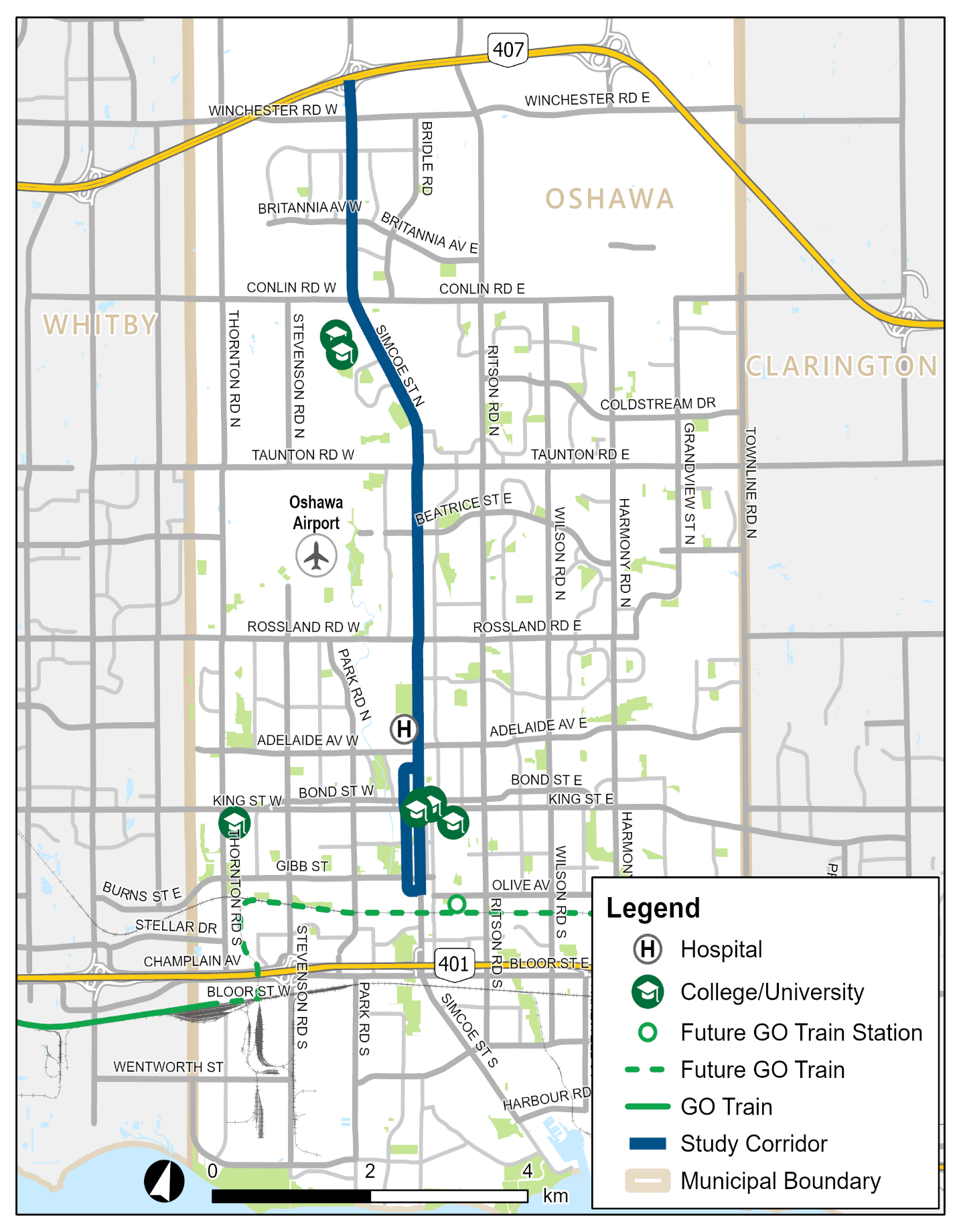
The Region of Durham’s 2017 Transportation Master Plan and Metrolinx’s 2041 Regional Transportation Plan both identify the need for a rapid transit corridor along Simcoe Street between Highway 407 and the proposed Ritson GO Station in the City of Oshawa.
In order to identify the most suitable form of rapid transit for the Simcoe Street corridor, the Region of Durham is initiating the Simcoe Street Rapid Transit Visioning Study. The Simcoe Street Rapid Transit Visioning Study is an opportunity to learn how to improve mobility and quality of life for existing residents while preparing the corridor to attract and support future growth.
This Study will investigate opportunities to realistically assess rapid transit investments based on evolving best practices in the areas of diversity, equity and inclusion including the equity economic benefits of rapid transit and Transit-Oriented Communities concepts.
The primary objective of the Study is to develop a concept plan, including preferred stations and connections, and a supportive rapid transit service strategy for Simcoe Street. The Study will also consider future transit planning initiatives by Metrolinx, transit agencies and regional and municipal authorities.
Study Area
The Study Area will be focused primarily along Simcoe Street between Highway 407 and Olive Avenue in the City of Oshawa.
Join the conversation
Visit the project webpage at www.SimcoeStreetRapidTransit.ca to:
- Learn more about the study
- Sign up for the mailing list
- Leave a comment on the interactive map
- Stay up to date on key milestones and opportunities to get involved
Contact Us
Email: [email protected]
Telephone: 905-668-7711 x 2198
Parking Study
The City of Oshawa has initiated a citywide Parking Study (the Study). Results of the Study will inform the development of a parking strategy that anticipates and accommodates parking demand through environmentally, socially and economically sustainable policies.
The Study is considering:
- parking requirements in the City of Oshawa Zoning By-law 60-94 for all residential uses throughout the entire city (e.g. required number of spaces, size, location of spaces);
- parking requirements in the City of Oshawa Zoning By-law 60-94 for all uses in the downtown (e.g. required number of spaces, size, location of spaces);
- the downtown municipal parking system, including future demand and future policies;
- the relationship between parking supply and specific goals for the City’s Urban Growth Centre, Transportation Hubs, Part II Planning Areas, as well as Corridors and Intensification Areas;
- recommend sources of funding or alternative financing measures available to the City to implement the recommendations;
- best practices from comparable municipalities;
- feedback from the community; as well as,
- businesses and other stakeholders to ensure concerns are identified and heard.
Resources
- Final Study and Appendices
- CNCL-21-110 City of Oshawa Parking Study
- CNCL-22-76 City of Oshawa Parking Study
Bloor-Simcoe Intensification Study
The City of Oshawa is undertaking a Bloor-Simcoe Intensification Study, the purpose of which is to develop an intensification policy framework to guide future development in suitable locations and at appropriate densities within the Study Area. The Study will include, but is not limited to, a review of the existing land use policy framework and current conditions of the Study Area, and to identify opportunities to accommodate future growth.
The Study Area consists of:
- The Bloor St. corridor - generally bounded by Hwy. 401 to the north, the Canadian National Railway corridor to the south, Farewell St. to the east and Park Rd. S. to the west; and,
- The Simcoe St. S. corridor - generally bounded by Hwy. 401 to the north, Wentworth St. W. to the south, certain commercial/institutional/residential zoned lands to the east, and the Oshawa Creek Valley to the west.
Documents
Included below are documents related to the Bloor-Simcoe Intensification Study. If you require a document in an alternate accessible format, please contact the City’s Planning Services using the contact information below.
How to Provide Feedback
Community members will have an opportunity to provide their feedback in the following ways:
- Attend a Public Open House on Tuesday, January 30, 2024 from 6:30 p.m. to 8:45 p.m. in the C-Wing Committee Room at City Hall (50 Centre St. S., enter from the main south entrance and immediately turn right).
- Two identical 30-minute presentations will be made – at 6:45 p.m. and at 7:45 p.m., each followed by 30 minutes for discussion and questions on the presentation.
- The presentation and display boards are available for viewing on Connect Oshawa (ConnectOshawa.ca/BloorSimcoe).
- Complete a feedback form on Connect Oshawa or on paper at Service Oshawa, located at City Hall (50 Centre St. S.).
- Complete a mapping exercise for the area on Connect Oshawa and submit your questions through Connect Oshawa
Feedback will be received until 12 p.m. on Friday, February 9, 2024 and will be considered in a future staff report to be presented to the Economic and Development Services Committee.
Contact Us
Victoria White, Principal Planner
905-436-3311 ext. 2945; [email protected].
Background |
Interim Control By-Law 133-2023 On October 30, 2023 Oshawa City Council considered Report ED-23-192 dated October 11, 2023, and adopted the following recommendation:
The Study Area generally consists of:
|
Frequently asked questions
What is intensification? |
Intensification is development that allows for more people to live, work and connect within a specific area. Check out the City’s Intensification Education Guide for more information. |
What is an interim control by-law? |
An I.C.B. is a tool available to Ontario municipalities under Section 38 of the Planning Act. An I.C.B. places a temporary hold on the development of certain lands while a municipality is studying or reviewing its land use policies. The temporary hold can only be imposed for a period of one (1) year, with a maximum extension of one (1) additional year. Once an I.C.B. is no long in effect, a subsequent I.C.B. may not be imposed on the same effected lands for a period of three (3) years. As a result of recent changes to the Planning Act, any person who was given notice of the passing of the I.C.B. may appeal to the Ontario Land Tribunal within fifty (50) days. |
Who is conducting the Study? |
The Study is being completed by City staff with input from the public and key stakeholders. |
How do I receive notification of future reports and/or decisions on this matter? |
If you wish to be added to the Notification List for this matter, please contact Planning Services at 905-436-3853 or by email to [email protected]. |
Completed Development studies
To obtain information about a completed environmental assessment, please contact Engineering Services.
- Northwood Land Use study
- Oshawa Creek Design study